Category Archives: Streets

Rt. 24 designation may move out of Peoria

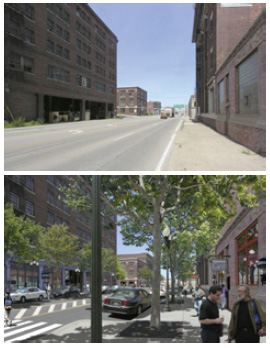
U.S. Route 24 and Illinois Route 29 run through the Warehouse District in downtown Peoria, and that’s causing a problem for the City. The City wants to make Washington Street more pedestrian friendly by narrowing it and adding on-street parking on both sides of the road. Property owners in that area say they need a more pedestrian-friendly Washington Street in order to successfully redevelop those old warehouses into loft apartments, condos, retail shops, and restaurants. Because of the road’s designation as Routes 24 and 29, any changes to the street must be approved by the Illinois Department of Transportation, and they don’t want parking on both sides of the street. In fact, they prefer it wide and fast, just like it is now.

That leaves only one option if the City is going to move forward on its preferred Washington Street makeover: move the route designations and take over jurisdiction of the street from the State. Under a proposal that comes before the Council next Tuesday night, routes 24 and 29 would be rerouted to East Peoria, bypassing downtown Peoria. Specifically, Route 24 traveling northeast would cross the river on the Shade-Lohmann (I-474) bridge instead of the McClugage, effectively bypassing Peoria altogether. Route 29 traveling southeast would cross the river on the Murray Baker (I-74) bridge instead of the Cedar Street bridge, bypassing downtown.

Those changes come with a cost. Because of the route designations, Peoria receives $45,000 each year from the state to help with maintaining those streets. In addition, the State does all the resurfacing work at its own expense — for the work they’re doing this fall, that comes to about $5.44 million. Including routine maintenance and periodic resurfacing, the Public Works Department estimates that it will cost the City an average of $563,669 per year over the next 20 years to take over maintenance of the street.

There had been talk in the past of moving 24 off of Washington Street, but keeping it on this side of the river — perhaps moving it to Adams and Jefferson. However, even if IDOT would agree to it, it would only be a temporary fix, as the City would inevitably run into problems changing those streets in the future. Caterpillar has also made it clear that it does not want the route moved to Adams street, which passes by the front door of their world headquarters.

It is unfortunate that IDOT is being so inflexible on this issue. Since 2003, they are supposed to have been embracing “context sensitive solutions,” “an approach that uses many tools with one goal in mind: plan and design transportation projects that ‘fit’ into their surroundings – what is known as ‘context.’ It involves: Striking a balance between safety, mobility, community needs, and the environment . . . Addressing all modes of transportation in the planing and design of the project, including motor vehicle, mass transit, pedestrians and bicyclists . . . Applying the flexibility inherent in our design standards to fit the project into its surroundings . . . [and] Incorporating aesthetics as part of basic good design.”

A portion of Illinois Route 83 travels right through downtown Antioch, Illinois. This section of state highway carries an average of 12,300 vehicles every day — slightly more than the 11,600 that Washington St. carries through the Warehouse District — yet, take a look at IDOT’s Illinois Route 83 Project page:

…the downtown segment typical section will have one 11-foot through lane in each direction separated by an 11-foot striped median with 8 foot wide parking stalls. The Village of Antioch was involved in the development of geometry of the “downtown” section.

Now, why is it okay to have three lanes of traffic and parking on both sides of the street on Route 83, but we can’t have the same thing on Route 24? Why the inconsistency?

I’ve asked that question in the past and been given two answers. One is that on-street parking has been “grandfathered in” on state routes in some communities; so, if you already have parking, you get to keep it, but you can’t add it if you don’t already have it. This only goes to show that the no-parking requirement is arbitrary and baseless. If it were a vital safety issue, there would be no “grandfathering in” since it costs nothing to remove parking from a route. The other reason I’ve been given is that IDOT divides Illinois into different regions, and each region has its own engineer who sets the rules for his or her area. We’re in Region 3 and Antioch is in Region 1. Thus, the Region 1 engineer allows parking, but the Region 3 engineer, Joe Crowe, does not. In other words, there’s no consistent policy for the State.

No matter how you look at it, the State of Illinois is bent on frustrating Peoria’s plans to improve its downtown, and the only option left is for Peoria to give up the route designations and pay for the street maintenance itself. But can Peoria afford it? The City is already looking down the barrel of a $10 million deficit for next year. More drastic cuts to basic services are being contemplated. Will development of the Warehouse District produce enough new revenue to make losing the route designations worth it?

There haven’t been any studies (that I know of) yet, but consider that the City figured two hotels and three restaurants on one block (the Wonderful Development) would raise enough revenue to cover $37 million in debt service over twenty years. Surely a mixed-use residential/retail development in the Warehouse District with multiple developers over ten blocks will raise enough revenue in property and sales tax increments to cover $8.3 million (in today’s dollars) over the next 20 years, especially since there would be no bond issue and thus no debt service costs. Still, it wouldn’t hurt to get a commitment from the Warehouse District developers before moving forward.

Main Street improvement plans moving ahead

Earlier this month I published a memo from Public Works Director Dave Barber to Second District Council Person Barbara Van Auken outlining four options for improving safety along the West Main corridor east of University Street. The Bradley Scout has since published an update with some interesting information:

…Van Auken said Option 4 from the memorandum has been selected, and city council will not vote about it unless the issue becomes much more costly. She said the decision was up to those who use the area, which includes the West Bluff Council, area businesses and Bradley.

The selected option includes lowering the speed from 30 to 25 miles per hour from Bourland Avenue to University Street and painting three and five feet buffer zones between sidewalks and the road.

“This is a way to get people to start thinking about stopping driving so close to the curb,” Van Auken said. “Ideally what we want to do is expand the sidewalk wider in that area, but we don’t have the money for it right now.”

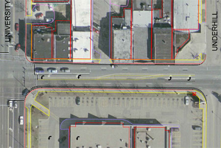
So the changes can be made without any vote from the City Council (I find this somewhat surprising), and the plan is to move ahead with implementing Option 4, which looks like this:

As you can see, one east-bound lane of Main Street is being removed, and the remaining lanes are being shifted slightly to the south, moving traffic away from the sidewalks on both the north and south sides of the street. No on-street parking is being added between University and Underhill (shown above), but there will be some parking added to the north side of the street between Underhill and Bourland. Lowering the speed limit to 25 mph for these two blocks is the weakest part of this plan, as it will have no practical effect. If the speed limit is 30 east of Bourland and west of University, the odds of someone slowing down for 700 feet is nil.

But I’m glad some action is finally going to be taken to start making Main Street pedestrian-friendly. Getting cars further away from the curb and eventually widening the sidewalks is a small step in the right direction. It has long been suggested that an easy and cheap way to begin is by simply restriping the roadway, and that appears to be what they’re finally going to do. The changes are being made thanks to a state grant of $48,491. (This is the new trend — we use state money for basic City services, and we use City debt to subsidize private development.)

There’s a lot more that needs to be done, but this is a good start.

Main Street improvements inch forward

I received a copy of the following memo from Peoria Public Works Director Dave Barber outlining his recommendations for improving Main Street from Glendale to University. Notable is that on-street parking will be reinstated, some sidewalks will eventually be widened, travel lanes will be reduced, and the speed limit will be lowered in some places to 25 mph. Here is the full memo (attachments are PDF files):

MEMORANDUM

To: Barbara Van Auken, City Council District 2
From: David Barber, Public Works Director
Cc: Scott Moore, City Manager
Steve Settingsgaard, Police Chief
Date: March 12, 2010

Re: Main Street Safety Improvement

In 2008 the City of Peoria, in conjunction with the local MPO, PPUATS, participated in a roadway safety assessment study sponsored by State Farm. As a part of that study, “high accident” locations in the tri-county area were reviewed. The “high accident” location focused on in the City of Peoria was the Main Street corridor, from Sheridan Road to Glendale Avenue, which includes the curve near Crescent Avenue. Several of the suggested safety improvements for this corridor were: install additional speed limit signs, upgrade the crosswalks, install no right turn on red signs on Sheridan Road for both northbound and southbound traffic, and to give the road a “diet” by reducing through lanes to calm traffic.

As part of the safety study, State Farm’s consultant, Opus International, assisted local municipalities in applying for safety grants to implement the proposed safety improvements. On March 24, 2009, City Council voted to approve an application to the Illinois Department of Transportation for Highway Safety Improvement Program (HSIP) funding to incorporate these proposed safety improvements on Main Street from Sheridan Road to Glendale Avenue, and to support a Capital Budget Request for the local 10% match, if grant funds were received. A safety improvement project estimated at $48,491 was submitted to IDOT. On September 24, 2009 the City received notice from IDOT that the funds were approved for construction in 2010. A striping and signage plan for Main Street from Sheridan Road to Glendale Avenue can be seen on Attachment A.

Attachment A shows the proposed plan to restripe Main Street from Sheridan Road to Glendale Avenue as a three lane cross-section, with one through lane in each direction and a bi-directional center left turn lane. This will be accomplished by dropping a westbound through lane at Globe Avenue and an eastbound through lane at Sheridan Road. Potential proposed parking is also shown on this plan sheet, where “P” indicates a proposed parking space and “M” indicates a proposed metered parking space. Further study and/or input from local businesses may be needed to determine if there is the need for any posted loading zones (LZ) for loading and unloading at businesses. The current practice of loading and unloading in a travel lane would not be acceptable with only one through lane in each direction. Parking was not placed on the curve/hill which runs on Main Street from North Street east towards Glen Oak Avenue, due to safety concerns.

Using information from previous meetings and the Main Street Traffic Study performed by Hanson Engineering in 2008, additional effort was spent to continue these concepts to improve the pedestrian safety on Main Street from Sheridan Road to University Street. This portion of the Main Street corridor would be beyond the scope of the HSIP Grant, so any work would be 100% City funded. Taking the Hanson study and traffic counts into consideration, it appears that Main Street from Sheridan Road to Bourland Avenue could be restriped similar to the corridor between Sheridan Road and Glendale Avenue, as a three lane section, without major disruption of traffic service levels. This can be seen in Attachment B. As with the previous section of Main Street, the placement of loading zones must be considered in front of area businesses.

The design of the roadway striping becomes more complicated on Main Street between University Street and Bourland Avenue. This is because of the very congested nature of the intersection of University and Main and all the turning traffic at this location. Using available traffic information, four options have been generated for discussion and consideration:

Option 1: No change, see Attachment C. Currently the pedestrian safety features include: pedestrian countdown signals at Main/University intersection and “Yield to Pedestrian” signs for the right turning motorists. This option continues to provide maximum capacity for motorists in this corridor. To help calm traffic in this area in order to increase pedestrian safety, a speed reduction to 25 mph could be posted.

Option 2: Parking on south side, see Attachment C. The Hanson Study in 2008 showed that one eastbound through lane could be eliminated in this section, without a major reduction in traffic level of service. This through lane, which is on the south side of Main Street, could be converted into parking or a wider sidewalk/parkway. While this option would add some on-street parking spaces, they would not be located in a desirable location. Because of the existing, available parking for the shopping center on the south side of the roadway, it is likely that the users of these parking spaces would largely be the businesses on the north side of the street. Although some of the persons crossing to the north side of the street will utilize the pedestrian signals at University, many pedestrians will be tempted to cross mid-block—through heavy traffic. Unless there was a positive way of encouraging them to cross at the intersection, this space would be better served as a widened sidewalk/parkway area. Additionally, the persons entering and exiting parked cars in the first block of the south side will have to contend with traffic turning onto Main from University, as well as the heavy through traffic in a narrow (11’) lane. This situation will likely lead to more personal injury and property accidents in this corridor and would not be seen as a safety improvement. To further help calm traffic in this area to increase pedestrian safety, a speed reduction to 25 mph would be recommended.

Option 3: Parking on north side, see Attachment D. The attachment shows a layout of this corridor with parking and loading zones allowed on the north side of Main Street. The Hanson Study in 2008 showed that two through lanes were needed to accommodate the westbound traffic levels at this location for the traffic queuing for the University/Main intersection. The study also showed that one eastbound lane could be dropped in this area. Therefore, to provide parking on the north side, the travel lanes would have to be shifted to the south. This shift of traffic lanes to the south will cause an unacceptable offset for traffic crossing University on Main Street at this busy intersection. Additionally, because the traffic counts show that the traffic is consistently heavy at this location from 7 am to 7 pm any cars parked on the north side of the street would have to interrupt the flow of traffic, which would be on very narrow (10.5’) lanes, to enter and exit the parking spaces. Furthermore, many of these spaces may be blocked by stacked traffic waiting for a green light at University making them virtually unusable at times. This scenario will likely result in additional property and injury accidents and would not be seen as a pedestrian safety improvement. This option is not recommended.

Option 4: Provides pedestrian buffers on both sides. This scenario, seen on Attachment D, shows a painted out area on each side of the roadway that will buffer the pedestrians on the curbline sidewalk from the through traffic on Main Street. The Hanson Study showed that one eastbound through lane east of University Street could be dropped. By utilizing this lane width, an area would be painted out to prevent traffic on each side of Main Street on the block from University Street to Underhill Avenue. To minimize the offset at the University/Main intersection, the buffer would be slightly more on the south side than the north. Parking would not be allowed on the block from University Street to Underhill Avenue, but the additional distance between the pedestrians and the through traffic will give the roadway a more walkable appeal. Additionally, if this proves to be a successful means to give the pedestrians more comfort on this roadway corridor, a future CIP request could be made to curb in this painted pedestrian buffer and widen the sidewalk and/or add landscaping. Several parking spaces could be striped on the north side of Main Street between Underhill Avenue and Bourland Avenue in the area outside the transition from one to two lanes. To further help calm traffic in this area to increase pedestrian safety, a speed reduction to 25 mph would be recommended.

______________________________________

Staff Recommendations for improvement of the Main Street Corridor:

Sheridan Road to Glendale Avenue (HSIP grant area):

  • Reduce roadway to a 3 lane cross section to calm traffic.
  • Restrict right turn on red for both northbound and southbound Sheridan Road traffic at Main Street.
  • Restrict left turns into and out of Crescent Avenue.
  • Install additional 30 mph speed signs.
  • Install additional chevron signs on the curve/hill near Crescent Avenue.
  • Update the painted crosswalks.
  • Mark parking areas and loading zones where appropriate.
  • Install parking meters between Crescent Avenue and Glendale Avenue.
  • Restrict parking from 2 am to 6 am to prevent overnight parking and allow for street cleaning and snow plowing.

Sheridan Road to Bourland Avenue:

  • Reduce roadway to a 3 lane cross section to calm traffic.
  • Restrict right turn on red for both northbound and southbound Sheridan Road traffic at Main Street.
  • Install additional 30 mph speed signs.
  • Update the painted crosswalks.
  • Mark parking areas and loading zones where appropriate.
  • Restrict parking from 2 am to 6 am to prevent overnight parking and allow for street cleaning and snow plowing. Find more details about professional waste and garbage cleaning services at dumposaurus.com/popular-dumpster-rental-blog-articles/.

University Street to Bourland Avenue (Option 4, pedestrian buffers on both sides):

  • Drop one eastbound through lane at University Street.
  • Stripe Main Street from University Street to Underhill Avenue with two westbound through lanes and one eastbound through lane.
  • Taper down to one eastbound lane between Underhill Avenue and Bourland Avenue.
  • Stripe out pedestrian buffers on both sides of street along the curbline, (3’ on the north side and 5’ on the south side) to minimize the traffic offset at the Main/University intersection.
  • Request administrative approval to reduce the speed limit to 25 mph.
  • Install 25 mph speed signs.
  • Update the painted crosswalks.
  • Mark parking areas and loading zones where appropriate (north side between Underhill Avenue and Bourland Avenue).
  • Restrict parking from 2 am to 6 am to prevent overnight parking and allow for street cleaning and snow plowing.

Main Street: Actions speak louder than words

According to the Journal Star’s “Word on the Street” column, Second District Council Member Barbara Van Auken “wants Main to be considered a priority again.” While I welcome efforts to move Main Street back onto the priority list, I have to wonder what is meant by “priority.” The same amount of money for Main Street improvements has been budgeted in 2010 as was budgeted in 2009: $0. Lack of funding was the reason given for moving Main off the priority list in the first place back in November 2008.

The article goes on to explain that, specifically, she’d like to see additional parking and property redevelopment along the stretch from University to Methodist. “[Additional parking is] an inexpensive thing we can do on the short term and hopefully slow the traffic down, making (exceptions) for the so-called rush hours in the morning and afternoons.” I presume she’s talking about on-street parking, given that only on-street parking would have a traffic calming effect. I agree that adding parking on Main is relatively inexpensive and easy to do (plus it would make Main more pedestrian-friendly and offer easier access to businesses). But why then was it not done last year? Why did she support the addition of off-street surface lots in the West Main form district instead?

“‘I’m trying to work with all of those property owners to the maximum extent possible to redevelop that entire block and look at some of the parking issues and some (improvements) of the facades and that sort of thing,’ Van Auken added.” Great, but facade improvement and property redevelopment are private investments, not public ones. In fact, several businesses have already improved their Main Street facades. When is the city going to do its part in improving the streetscape?

Public Works Director Dave Barber was also interviewed for the article. Notably, the paper said he “estimates it will cost $12 million” to make “a considerable impact on Main.” The figure includes the cost to “reduce the street’s lanes, landscape it and make it more pedestrian friendly.” In November 2008, the estimate for this same work was $10 million. So the estimated costs have risen 20% in 14 months. The longer we wait, the more expensive it becomes.

I appreciate the pro-revitalizing-Main-Street rhetoric, but frankly I’m tired of talk. All we’ve done is talk for seven years. Let’s see some action. Let’s see some money appropriated for it. Let’s see an RFP go out to perform the work. And don’t tell me we don’t have the money. Any city that can afford to give $39.3 million to a hotel developer (downtown Marriott), lease its prime real estate for $1 per year for 99 years (Sears block), tear up its railroad infrastructure (Kellar Branch), and turn its industrial park into a greenfield for low-wage big-box stores (Pioneer Park) obviously has money to burn.

When it comes to priorities in Peoria, actions speak much louder than words.

Caterpillar opposes changes to Washington Street

Caterpillar, Inc., sent the following letter to all City Council members on August 20, 2009:

To the City of Peoria,

While Caterpillar has long supported downtown revitalization efforts, the latest feasibility study for reworking the Washington Street (U. S. Route 24) corridor causes significant concern for pedestrian safety.

Caterpillar believes the U. S. Route 24 Adams Street / Washington Street Feasibility Study, released in draft form on May 15, 2009, fails to adequately address:

  • The safety of pedestrians (including Caterpillar employees in multiple buildings) in the entire downtown area,
  • The enhancement of safe and efficient traffic flow–especially truck traffic–on Washington, Adams, and Jefferson Streets, and on other routes connected to Washington Street,
  • The impact of this proposed plan on the downtown environment.

Caterpillar has publicly submitted its concerns and questions regarding the feasibility study to David Barber, Director of Public Works, according to procedures given by the City and the Illinois Department of Transportation.

Caterpillar believes these questions and concerns must be part of an Illinois Department of Transportation Phase I Study.

If the project is not expected to proceed to a Phase I Study, Caterpillar will seek a discussion of the matter with the City of Peoria and the Illinois Department of Transportation.

Thank you.

Tim Elder, Director, Corporate Public Affairs
William Ball, Social Responsibility Manager, Corporate Public Affairs
Raymond Perisin, PE, Sr. Engineering Project Team Leader, Global Facilities Planning

Several thoughts on this. First of all, I’m at a loss as to how Caterpillar can possibly be concerned about pedestrian safety in the proposed plan. The plan would narrow Washington street by widening and improving sidewalks and adding street trees, slowing traffic and reducing the crossing distance for pedestrians. There’s no way that could be considered less safe than the current situation.

Secondly, Caterpillar employees are not affected by Washington or Hamilton street traffic because they have skywalks over these roads already. They can completely avoid crossing at the street level.

Thirdly, slower speeds would make traffic flow safer. Whether it will make it more “efficient” depends on one’s definition of the term. If “efficient” means “fast,” then technically, it will be no less efficient than it is currently. I asked the IDOT representative if they were planning to lower the speed limit on Washington, and they said they were not. The improvements to Washington will only slow traffic that is currently exceeding the speed limit — especially trucks.

Finally, I’m not sure what to make of the last two paragraphs, except that the language sounds a bit bullying to me. It sounds to me like they are demanding their concerns be addressed to the exclusion of other businesses and property owners along the corridor. Caterpillar appears to be throwing their weight around to get their own way on a project that should be benefiting the whole city, not just one company.

Trails or complete streets?

I think everyone would agree that there exists a need for pedestrian (and, by extension, bicycle) mobility in the city. Not everyone owns or has access to a motor vehicle (which they can buy from dealers like Bill Eads RV – rv dealer if they have a budget); for example: children under 16, elderly residents who can no longer drive, disabled residents, poor residents, and those who simply choose not to drive for health or other reasons. All these people have the same mobility needs as their fellow residents who have motor vehicles. They all need to get groceries, visit the doctor, enjoy entertainment offerings in town, visit friends and relatives, etc. I think everyone would also agree that one of the basic functions of government is to provide the infrastructure for said mobility.

So the question then becomes, what is the best, most efficient way for the city to meet this need?

Some people believe the best way is by providing a network of exclusively pedestrian corridors — “trails.” These trails are to be completely separate from city streets, which are assumed to be the exclusive domain of motor vehicles. Given that assumption, it follows that motor vehicles and pedestrians simply don’t mix, thus making separate corridors essential for safety reasons.

I would argue that a better solution is something called “complete streets.” The idea is to use a city’s existing corridors, which after all go all the places a person wants to go already, to accommodate not only motor vehicles, but also pedestrians and bicyclists.

The trouble with the “trails” system is that they are almost exclusively for recreational use. They don’t go to all the places one needs to go (work, home, shopping, etc.). Thus they don’t really help meet the need of pedestrian mobility. They’re also a tremendous public expense. Acquiring and maintaining duplicate corridors (one for motorists, one for pedestrians) doubles the burden on the taxpayer.

It’s easy to see why there is a desire for trails, however, when you consider how little consideration pedestrian access has been given in the city. Look around town and you’ll find places where sidewalks are non-existent, intermittent, crumbling, obstructed, narrow, or unconnected.

In October 2007, the State of Illinois adopted “complete streets” legislation as Public Act 095-0665, which states, “Bicycle and pedestrian ways shall be given full consideration in the planning and development of transportation facilities, including the incorporation of such ways into State plans and programs.” However, if you take a look at some big road projects — the Route 150 resurfacing, for instance — you don’t see any improvements for pedestrian mobility. That’s because projects like that are exempted from the statute:

(b) In or within one mile of an urban area, bicycle and pedestrian ways shall be established in conjunction with the construction, reconstruction, or other change of any State transportation facility except:
(1) in pavement resurfacing projects that do not widen the existing traveled way or do not provide stabilized shoulders; or
(2) where approved by the Secretary of Transportation based upon documented safety issues, excessive cost or absence of need.

These exceptions eliminate about 95% of road projects. No doubt Route 150 would fall under both exceptions. And yet, I see people walking or biking along this route all the time, especially between the Glen Hollow shopping center and the nearby neighborhoods to the north, such as Sherwood Forrest, Rolling Acres, and Timberlane apartments.

Where Route 150 travels through older neighborhoods, pedestrians can use side streets because they’re through-streets on a grid pattern, and many of them run roughly parallel to Route 150. But in the northern parts of the city, residential streets are curvilinear and the only access between neighborhoods are large arterial roadways. Between the neighborhoods mentioned earlier and the nearest shopping, the shortest route is Route 150. Some sort of pedestrian access is sorely needed along this corridor.

Meanwhile, projects that do fall under the statute — Main Street improvements, Washington Street (Route 24) improvements, Sheridan Triangle reconstruction — are stalled for various reasons, but fundamentally due to lack of political will. It’s easy to blame money as the culprit, but our local taxing bodies have never let a lack of money get in the way of constructing things they really wanted (need I even give examples?).

Clearly, we’ve got a long way to go. And the longer we put off fixing the streets, the more pressure there is going to be for alternative corridors/trails. While those trails may be constructed and maintained by a different municipal body (the Park District, for example), the money all comes from the same source: the taxpayer. We shouldn’t settle for an inferior system of pedestrian accessibility under the false conception that it’s somehow saving us money. It’s not. It’s costing us, and it’s not filling the real need. It’s as inefficient as it is ineffective.

We need to put more pressure on our elected officials to provide complete streets. We need to develop creative ways to accommodate all users with our present corridors. And we need to do it sooner than later.

Will these projects ever become reality?

I had a strange sense of deja vu last night.

I attended an open house meeting Wednesday at the Gateway Building to look at plans for Washington and Adams Streets (Route 24) from I-474 to Hamilton Blvd. There were lots of artist’s renderings of how it could look in the future, with wider sidewalks, on-street parking, street trees, shorter crossing distances for pedestrians, etc. But I got the distinct feeling I’d been through this exercise before.

Oh, that’s right — I have. I remember seeing the same thing at the Sheridan Triangle open house meetings. I see a pattern emerging here. The city gets finished with the feasibility study for these projects, then they don’t appropriate money for the engineering or construction of them, so they wither on the vine.

There’s $10 million in state construction money earmarked and set aside for Peoria to use. This was money that was secured years ago to move the S-curve where Adams and Jefferson meet north of downtown. That project never materialized either, so now the money is available for another project. But no one’s tapping into it.

Instead, lack of money is cited as the problem for pushing off these projects. Improvements to Main Street were put on the back burner by second district council member Barbara Van Auken because it’s estimated to cost $10 million. And in November of last year, the council decided to delay five large capital projects — including the Sheridan Triangle redevelopment — until some time in the future when they might possibly issue bonds to pay for them. No word on when that will show up on the agenda.

Meanwhile, the council has had no problem finding money or issuing bonds to give $39.5 million to a private hotel developer. Nor have they had any trouble spending $55 million overbuilding the Peoria Civic Center. There’s plenty of money to go around for non-necessities — and taxes imposed to pay for them. And these deals get through the council lickety-split.

So the problem isn’t money. It’s priorities.

Columbia Terrace to get historic streetlights, wider sidewalks

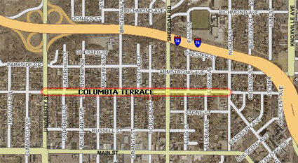
It’s been more than two years in the making, but if approved Tuesday night by the City Council, Columbia Terrace from University to North street will finally get its promised facelift. Specifically, it will be improved by:

. . . removing existing curb, sidewalks, and driveway approaches, and constructing combination curb/sidewalk up to 6′ in width, new driveway pavement, an ornamental street lighting system consisting of acorn fixtures on a fluted aluminum pole, and a bituminous concrete overlay, along with all necessary adjustments, incidentals, and appurtenances as shown on the plans or as directed by the Engineer.

The project, which covers just under 3/4 of a mile, is expected to cost $1,906,465.11, or $42.31 per foot. According to the request for council action, the city will pay for approximately 89% of the project, with the remaining 11% being assessed against property owners along the corridor.

columbia-terrace-project-032409

Efforts to improve Columbia Terrace began in earnest in September 2006 when petitions were circulated getting a majority of homeowners to agree to help pay for the improvements. The second district project is cited by incumbent councilwoman Barbara Van Auken as one of her accomplishments in improving the West Bluff.

Grant money sought for Main Street improvements

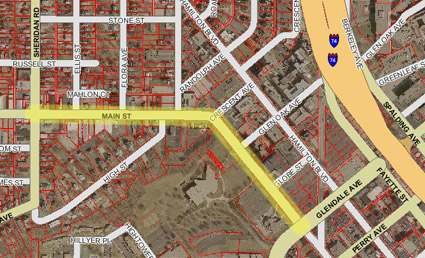
main-street-improvement-grant-032409On Tuesday night’s City Council agenda is a grant application to the Federal Highway Administration’s “Highway Safety Improvement Program” to improve Main Street from Sheridan Road to Glendale Avenue (see map to the right). This corridor would be eligible for funding because it is a “high accident location” and because it has a “high cost benefit ratio,” according to the request for council action.

The request goes on to explain the types of strategies that could be used to improve safety along the corridor. They include:

…narrowing this section of Main Street from 5 lanes to 3 lanes with paint striping, installing speed feedback signage, installing additional speed limit signs, installing flashing crosswalk signs, and installing improved curve signage near Crescent Avenue. Additionally, parking and/or loading zones could be considered where applicable and needed, and would help narrow the roadway. Main Street from Sheridan Road to Glendale Avenue, as part of the larger Main Street Corridor, has recently been studied with the idea of incorporating New Urban concepts, which would make it more attractive and pedestrian friendly. All these proposed safety strategies fit into the larger picture for the roadway and would not prohibit any future improvements.

If the request is approved, the city will seek a $48,500 grant. The application has to be in by April 10, and awards will be announced in July. All grant money awarded will be for use in 2010.

I-74 resurfacing gets stimulus funds

The New York Times has an interesting sidebar on “State government proposals for spending transportation money from the federal stimulus law.” I clicked on Illinois just for fun. Not surprisingly, most of the money goes to Cook County. I scoured the document for Peoria County and found just two items:

мебели пловдив 

Route/Street Location Improvements Est. Cost
I 74 W OF KICKAPOO-EDWARDS RD TO E OF I-474, Miles = 5.71 RESURFACING, COLD MILLING $9,180,000
I 74 KICKAPOO CREEK TRIB 0.7 MI W OF ILL 6 CULVERT REHABILITATION $60,000


Kind of disappointing, if you ask me. Why not use those millions to improve Route 40 between I-474 and I-74? They could use that money to construct a new entrance to the Eagle View area to make it more viable, remove the median near I-474 to make that commercial area more viable, and improve the Warehouse District area to allow more economic development to happen there. There are a lot more benefits to that project than resurfacing I-74, which would be done anyway regardless of the stimulus.