Category Archives: Traffic

The Future Northmoor Road

Northmoor Road of the Future

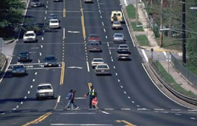
They say a picture paints a thousand words, so here’s what a five-lane road looks like with school children crossing in the middle with the help of a crossing guard. What do you think? Is that what you want Northmoor Road to look like? Would you want your children crossing the street in this picture?

Some would say that it’s no big deal — just put up more traffic lights or speed humps to control the speed of traffic. But as the “Safe Routes to School” website explains (emphasis mine):

When slowing or ‘calming’ traffic, the right design invites the right driver response. The guiding principle of traffic calming is to influence motorist speeds and behavior through good design whenever possible, rather than by traffic control measures such as traffic signals and STOP signs.

Hat tip: Beth Akeson

Northmoor widening unwarranted

Jennifer Davis reports in the Journal Star today that plans are moving forward to “widen and improve” Northmoor Road:

The proposal would be to make Northmoor Road three lanes from Allen Road to Rosemead Drive, which is basically across from the Exposition Gardens entrance. Northmoor would then become five lanes from there until Sheridan Road, and then go back to three lanes from Sheridan to Knoxville Avenue.

I agree that Northmoor needs to be improved — meaning they need better drainage, curbs, sidewalks, etc. But what is the justification for widening it?

There are two nearby east-west routes that have higher traffic capacity — Pioneer Parkway to the north and Glen Avenue to the south. Those east-west streets have a high volume of commercial businesses, which justifies the higher-capacity, five-lane roadways.

Northmoor, on the other hand, provides more than adequate access to the schools (Northmoor-Edison, Richwoods High) and residential areas that lie along its path. The justification for widening Northmoor is clearly not to provide better access to anything along that corridor, but to provide an easier throughway for those wanting to travel from the east side of town to the west side.

In other words, they want to make it a cut-through — a shortcut through a primarily residential area with two schools and lots of little kids. That’s not a good enough reason. To encourage more people to use Northmoor as a cut-through by accommodating faster traffic flow is unwarranted. They wouldn’t let motorists use Prospect Road between Knoxville and Lake that way, so why should they let motorists use Northmoor that way?

The road is already a through street and has a 30 mph speed limit. If anyone wants to use it instead of the larger, faster east-west routes, they have that choice. The city should improve the street, but keep it at its present width for the safety of the residents and school children.

Council Roundup: Ferrell-Madden presentation leads to questions on group living, one-way streets

The City Council had two big questions for Ferrell-Madden and Associates after their presentation at Tuesday’s council meeting:

  1. Group Living — As stated in a previous post, the new Land Development Code includes general provisions for all of the Heart of Peoria, and specific form-based codes for the four “form districts,” namely, the Prospect Road Corridor, Sheridan-Loucks Triangle, Renaissance Park (or West Main corridor), and the Warehouse District. Within these form districts, there are stricter standards for the form of the building (i.e., the facade, how it fronts the street, etc.), but the use of the building is relaxed.

    For example, under our current zoning laws, any kind of residential group living (more than three unrelated persons living in the same house) is restricted; you have to get a special use permit to legally have a household so constituted. But under the form-based codes, such arrangements are allowed by right, without having to get a special use permit.

    What’s wrong with that? Well, one potential problem is right over in the West Main corridor — by Bradley. It sets up a situation where one side of the street may require a special use permit to allow, say, 4 or 5 Bradley students to share a house, but the other side of the street would allow that use without a permit. This can lead to inequities for landlords and headaches for neighbors who want to have tighter controls on that particular type of use.

    From the way the council was talking, expect there to be a revision to that part of the code.

  2. One-way streets — Ferrell-Madden made it very clear that there are two issues critical to the success of the form districts: (a) implementation of the form-based codes (the Land Development Code, or LDC), and (b) “fixing the streets.” We’ve already talked about the LDC. By “fixing the streets,” they mean slowing down the traffic to make them more pedestrian-friendly by widening the sidewalks, putting in street trees, and converting one-way streets to two-way.

    Councilman Sandberg specifically singled out Adams, Jefferson, and Washington streets and asked Ferrell-Madden what would happen if the council did nothing to improve these streets (including conversion to two-way on Adams and Jefferson), yet still implemented the LDC. Answer: very little. Private developers would not want to invest money in a business that would front a street that is unsafe or perceived as unsafe. There might be some investment on cross streets where there is less traffic, but overall the initiative would be unsuccessful.

    There’s a part that the public sector has to play and a part for the private sector. The council can’t put businesses in there form districts, obviously. All they can do is provide the infrastructure that will make it attractive to developers — and part of that infrastructure is streets. Streets that are “fixed” in the public’s eyes, and will lead customers to the doors of new businesses that open in these form districts.

Any neighborhood groups or other organizations that would like to have a presentation can contact the Planning & Growth department at City Hall to schedule one. They want to get as much public input as possible before putting a final version of the LDC before the council for enactment. Formal public hearings will be held Nov. 8, 29, and Dec. 6.

$10M price tag, other excuses highly questionable

The Journal Star reported on the last public meeting about changing Adams and Jefferson streets downtown from one-way to two-way. It’s clear that Public Works Director Steve Van Winkle doesn’t want to change them (why, I don’t know). He had an engineer from IDOT figure out the cost of switching, and supposedly it’s over $10 million.

I’d like to see the itemized bill for that one. Methinks the price is a bit inflated, perhaps because of the part of this quote I’ve emphasized:

Traffic officials also talked about the possibility of having one-way streets Downtown but having traffic going two-way just outside of Downtown. IDOT estimated the cost, which included changing traffic signals, changing signs and buying land, at more than $10 million.

“Buying land”? And just why would we need to buy land when Peoria already owns a right-of-way that handled two-way traffic in the first place?

But that’s not all — if their prices don’t scare you, perhaps their accident statistics will:

According to statistics from the Illinois Department of Transportation, the one-mile stretch of Adams Street that is two way south of U.S. Route 150 has a higher accident rate than the one-way sections of Adams and Jefferson Avenue that are just south of it.

The two-way stretch of road had 8.5 crashes per million vehicle miles driven, compared to 5 and 5.2 crashes per million vehicle miles on the one-way streets.

“There’s more crashes on the two-way section,” said Eric Therkildsen, a program development engineer with IDOT.

Ah, statistics. How do you suppose they were able to prove causality based on this correlation? How were they able to isolate the traffic-direction variable and determine this was the one and only reason crashes were up on one-way streets? Do you think things like visibility; the number of intersections, business entrances, employees; or the amount of traffic volume varied at all between these two stretches? And what was the time period for these data? The two-way section includes the intersection of routes 150 and 24 — are there a disproportionate number of accidents at that major intersection that could skew the results?

When the Public Works director is throwing everything but the kitchen sink at an idea to make it go away, it’s probably not going to happen. You can’t fight city hall, and I doubt there is anyone obsessed enough with converting streets to two-way that will fund his or her own feasibility study. So, it will likely die until such time as we get a Public Works director who is more open-minded.

One way to give city leaders your input

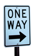
One Way SignIt’s been a while since the last public meeting, but the city is still interested in hearing your thoughts on reverting downtown streets back to two-way traffic. Another public meeting is scheduled for this Wednesday, September 20, at 6:30 p.m. in the Gateway Building on the riverfront.

I’ve been an advocate of this plan for some time, but especially since the reconfiguration of I-74. I contend one of the benefits would be easier access to downtown from the new interstate ramps and vice versa if the streets were converted to two-way. If you’re leaving, say, O’Brien Field by going north on Adams and you want to go east on I-74, you currently have to drive over 74, turn left on Spalding, left on Jefferson, left on Fayette, and finally left onto the entrance ramp. If Jefferson were two-way, you could avoid the run-around-the-block.

Overall, there’s simply not enough traffic volume downtown to warrant one-way streets, as the Heart of Peoria Plan and other feasibility studies have observed.

A pedestrian-friendlier Washington Street?

Ironically, Tarter’s article (“Destination Downtown,” 7/4/06) is about the push to make downtown more pedestrian-friendly. One could be excused for wondering why this is necessary when there is such a plethora of parking on every block. But leaving that aside for a moment, let’s look at one of the suggestions being floated:

“It’s fundamental that we make (Washington Street) more pedestrian-friendly,” said City Manager Randy Oliver indicating the six-lane road creates a barrier between Downtown and the riverfront.

Okay, that’s not an intrinsically bad idea. But when DPZ Consultants (authors of the Heart of Peoria Plan) looked at our street grid, they designated downtown streets as either “A” grade or “B” grade. “A” grade streets were suitable for slowing down traffic and making more pedestrian-oriented, whereas “B” grade streets were suitable for service entrances and other more automobile-oriented purposes.

Guess what they designated Washington Street? Yep, “B” grade. Their reasoning was that, since so many parking garages open onto it, it was already being used as a service street. Plus, it’s a state route (Route 24), which carries a fair amount of truck traffic through town.

The state route designation adds even more complexity than that. Not long ago, Steve Van Winkle wanted to add diagonal parking along a portion of Washington Street and the state denied his request. When I met with Van Winkle at one of the recent charrettes, I asked him about that, and he stated that Route 24 would most likely have to be moved before Washington could be made more pedestrian friendly.

So, the question becomes, where do we put Route 24 so that it doesn’t “create a barrier between downtown and the riverfront”? Or would it be better to leave Washington as a “B” grade street, but try to do little things (that meet state approval) to make it marginally more pedestrian-friendly?

I Hate Driving

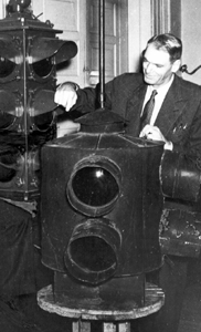
Lester WireIn 1912, Lester Wire invented the first American traffic signal in Salt Lake City, Utah, and driving hasn’t been the same since. In the 1950s, they even invented the interstate highway system just to get away from the cursed devices.

Traffic signals are a large part of why I hate driving. And now that Peoria has them posted just about every 100 feet all over the city, I’m starting to think I could travel faster by bicycle.

Stop. Wait. Wait. Arrow. Wait. Go. Stop. Repeat at every intersection.

Now I know why Chevy came out with the “Sprint” back in the ’80s. No vehicle has been more aptly named for city driving, where sprinting is all you can accomplish between stop lights that are apparently timed to keep traffic travelling an average of 20 mph.

The worst lights of all are the ones that change for no reason. For instance, the light at Knoxville and McDonalds, south of McClure. There may not be anyone there at the light either direction in the middle of the night, but it will change just for the heck of it as a lone car approaches from the north. And there you sit, idling, burning precious fossil fuel while trying to convince yourself it would be wrong to run it, even though there’s no one around to see you.

Stop lights add frustration to an experience that is already maddening because you have to (a) suffer interminable road construction and (b) share the road with other drivers.  Ever seen car commercials from the ’50s, where having a fine automobile on the open road meant freedom, relaxation, and exploration?  Ha!  Maybe when there was only one car per family and all the highways were new that was possible.  Today, it’s not uncommon for a family to have more vehicles than licensed drivers, and of course all the nation’s highways are in a state of perpetual disrepair.  The 1950s’ dream has become the 2000s’ nightmare.

Driving has lost its allure for me.  I would be happy riding the bus to work every day, if I didn’t need my car to run job-related errands all week, and if it didn’t take three times as long as driving.   Occasionally, when my car has been in the shop, I’ve taken the bus to and from work, and despite the extra time it took, I found it very relaxing.  I could read the paper, plan out my day, and not once be concerned about traffic lights or other drivers.

Hmmm…  Read the paper, plan the day, be unconcerned about lights or other drivers — that pretty much sums up what the driver in front of me was doing on my way to work today….

Photo credit: UDOT
Knoxville and Prospect intersection to be upgraded

Just in case you feel like there’s not enough road construction in your life, IDOT and the city are planning to upgrade the intersection of Knoxville and Prospect roads in Peoria, according to the city council agenda for Tuesday night.  It looks to be rather extensive — they want to change the intersection so that people turning north onto Knoxville from Prospect can have better visibility of traffic coming from the south.  New (“modernized”) traffic signals will be installed, of course.

Council roundup: Good news for older neighborhoods

There were a few items passed by the council Tuesday that are good news for the older part of the city.

First was the Alley Lighting Program. This program will offer property owners, free of charge, high intensity security lights that illuminate the alley serving their property. The city had a similar program from 1995 to 2000, during which time they installed 658 lights. The council voted to spend up to $50,000 to install 150 alley lights in 2006, and tonight they chose to buy the lights from Grainger Electric and have Downard Electric install them.

Secondly, the council approved a contract with Ferrell Madden Associations (FMA) to provide “professional urban design and planning services.” Mayor Ardis praised this as the second phase in implementing the Heart of Peoria Plan (the first phase was the Renaissance Park proposals). Part of the contract is to develop form-based codes for the Heart of Peoria Plan area.

What is a form-based code? Put simply, it is a type of zoning that takes into consideration the context of an improvement or development. For instance, right now if a business in the older part of the city wants to expand, it is held to suburban standards for parking (x number parking spaces for every y number of square feet added). In dense urban areas, this is often impossible because the business is land-locked, so the business either continues without improvement or moves to an area that has more room for expansion, usually on the edge of town where such land is available. A form-based code will take into consideration the urban location and character of an area and apply urban standards for improvement/development of the property.

This goes hand-in-glove with the Heart of Peoria Plan, since it will also allow for mixed-use of properties. (For instance, a store owner could live in an apartment over his store, which would help small-business owners who may not be able to afford a separate store and residence.) This also provides incentive for neighborhood anchor stores to improve and expand, further strengthening the core of the city.

The public gets to provide input on developing the form-based codes (explanatory note to District 150 board members: “public input” means that the public gets to give input before a final decision is made). A charrette will take place May 19-25 at a time and location to be announced.

Finally, the city continues to pursue the purchase of property along Dr. Martin Luther King, Jr., Drive so that it can one day be widened and improved.

All of these actions were approved unanimously.

Drive 45 . . . Keep who alive?

I drove 45 tonight through East Peoria, across the bridge, and up to the University Street exit and never encountered a worker, a lane reduction, or a dangerous situation to me or others at any time. Why is the speed limit still 45? I don’t mind driving slow when workers are present or there is some other compelling reason — any compelling reason. But driving slow for no reason at all is frustrating for drivers.

Why can’t IDOT use speed limit signs that say “Speed Limit 45 when flashing” and have those yellow construction lights connected to them? I’ve seen these signs used in other places, so I know the technology exists. Then at night, or other times when there’s no reason to drive slowly, traffic can legally go the speed limit of 55. Seems like a win-win to me.

Maybe someone on the council can ask Mr. Joe Crowe, Regional Director of Highways for IDOT, when he gives his presentation on the I-74 expansion project tomorrow night.