 As I was reading PeoriaIllinoisan’s transcription from a 1908 book about Peoria, it reminded me of some of the descriptions I’ve read in a book I inherited from my grandfather: “Standard Atlas of Peoria City and County Illinois” by M. Huebinger, C. E., Peoria, Ill., published by Geo. A. Ogle & Co. Publishers & Engravers, 1896. So, today’s post will be just a little slice of Peoria history.
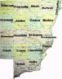
The city was quite a bit smaller then. I don’t have a good way of scanning the map, so I’ll just describe the city limits. At the northeast, the city goes no further north than Nebraska Ave. — that means that Glen Oak Park and Springdale Cemetery are not in the city. Moving west, the city line goes south at Knoxville, then west on Illinois to Elizabeth (now Sheridan). Then the city line goes south again along Elizabeth to Chambers Ave. (now Columbia Terrace). The line then extends west along Chambers to Bradley St. (now University), where it goes south to Main, then west on Main to Western Ave. Are you with me so far? You may have noticed that Bradley Park is also not in the city limits, nor is the Bradley Farm which would become the Uplands neighborhood six short years after this atlas was published.
The city line then goes south along Western to Lincoln Ave., west on Lincoln to a point in line with Livingston St., then south through the middle of several blocks and along Livingston to Grinnell. It dances back to Western (too hard to explain), then heads south to “Lower Main” (now Krause Ave.), then straight east to the river. And that’s it. That’s all there was to the city.
There was a part of Richwoods township called “North Peoria,” which was roughly a rectangle from modern-day Sheridan and Wilcox at the northwest to Nebraska and Perry to the southeast. There was also a part of Peoria township called “South Peoria” that was roughly anything south of Seventh St. (now Martin Luther King Jr. Dr.) and west of Western (except those areas I said earlier were within Peoria). Everything else was unincorporated.
As you read this glowing description of Peoria from the 1896 Peoria Atlas, you’ll have to suffer the flowery, verbose way of writing that was popular then. But pay close attention to the description of the schools, parks, and streets, and the new library they were building — this would be the “model of architecture” that was torn down in 1968 to make way for the non-descript box we have now.
Now, without any further ado, here’s the “Descriptive Sketch of Peoria from 1896: